Name
ST_Locate_Between_Elevations — Returns a derived geometry whose elevation are in the specified Z range.
Synopsis
geometry
          ST_Locate_Between_Elevations(
bytea
Geometry, double
start_Z, double
end_Z);
Description
Returns a derived geometry whose elevation are in the given Z range.
Coordinate Dimensions
| 2D | 3D | M |
|---|---|---|
 | | |
Spatial Standards Support
| OGC SFS for SQL. 1.1 (1999) | OGC SFS for SQL. 1.1.0 (2005) | OGC SFS for SQL. 1.2.0 (2006) | SQL-MM Part 3 |
|---|---|---|---|
| - | - | - | - |
Examples
SELECT ST_AsEWKT(geom)
	FROM
	(SELECT ST_Locate_Between_Elevations(
		ST_GeomFromEWKT('MULTILINESTRING ((1 1 2 8, 2 1 4 0, 3 1 5 2), (4 1 2 2, 5 3 0 -4, 8 8 0 -6))'),2,4) As geom)
As foo;

--Result
GEOMETRYCOLLECTION (LINESTRING (1 1 2 8, 2 1 4 0, 2 1 4 0), POINT (4 1 2 2))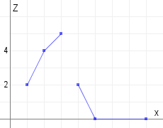 | 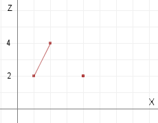 |